From seismic to heat in two years; Bringing complex urban geothermal projects to life
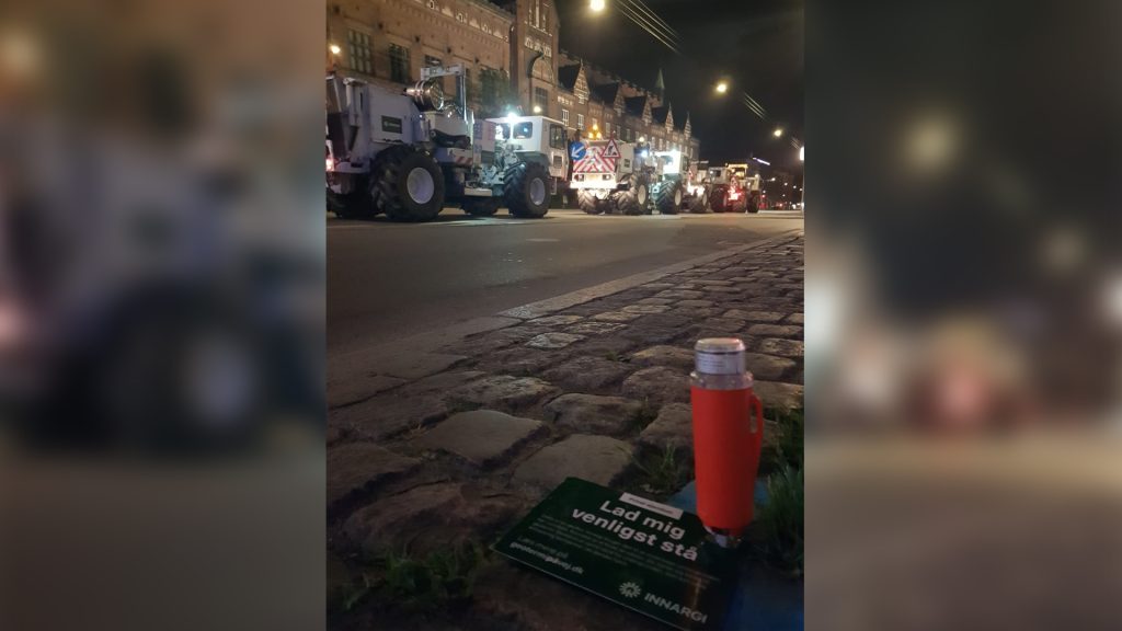
 Seismic trucks in front of the Danish Parliament in downtown Copenhagen. Photo courtesy of Innargi's Jesper Giørtz-Behrens


Seismic surveys done in large cities in Denmark have highlighted the flexibility of the technology, facilitating rapid data gathering and project development.
Geothermal energy is playing a crucial role in decarbonizing district heating. At the forefront of this transition is Innargi, a leading European geothermal developer dedicated to decarbonising heat—one community at a time.
With the economics of geothermal energy demanding a swift transition from design to heat production, where tighter budgets necessitate faster project timelines, Innargi is setting a new benchmark for this with two large-scale geothermal projects in the city center of Aarhus and North of Copenhagen.
Impressively, their first geothermal plant in Aarhus is planned to deliver its first heat in September 2025, just 26 months after the seismic acquisition ended—showcasing the speed and efficiency needed to make geothermal a scalable and impactful clean energy solution.
Once completed, these projects will collectively deliver over 130 MW of heating through 19 geothermal wells, reducing CO2 emissions by more than 165,000 tonnes annually.
Emil Stürup-Toft, Lead Geoscientist at Innargi, and Claudio Strobbia, Chief Research Scientist and CEO of RealTimeSeismic (RTS), shared their insights on these pivotal geothermal exploration campaigns, showcasing what it takes to image the subsurface and scale geothermal energy to this level in two of Denmark’s largest cities.
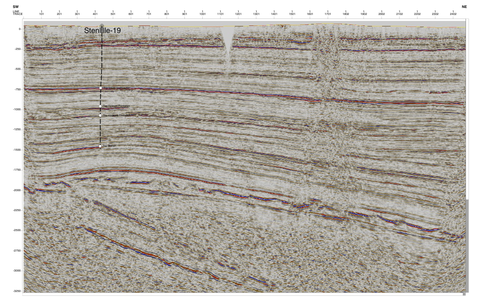
The importance and impact of the seismic data
“Before acquiring seismic data, we were operating with limited subsurface knowledge in Copenhagen. We knew geothermal potential existed—thanks to a well drilled 25 years ago that had performed beyond expectations —but we lacked certainty about the extent of the geothermal system. Seismic wasn’t a deciding factor in whether to pursue the project, but rather a crucial tool to confirm our geological model.” Emil explained.
“We needed to verify whether the productive system extended far enough north and south, as we had hoped. We also knew a basin-bounding fault ran through the center of Copenhagen, but we required precise imaging of its location, as this fault significantly influences geothermal potential on the city’s eastern and western sides.
“Seismic data proved invaluable in identifying areas with geothermal potential and refining our understanding of the system’s extent. A positive surprise was that the system stretched even farther than expected, both north and south, reinforcing confidence in our development plans.
Emil also commented on the need for seismic in Aarhus: “In Aarhus, the seismic survey played a critical role in refining our drilling strategy within the pre-selected area for geothermal development. With the site already contracted, the data was essential for pinpointing the most suitable drilling locations, ensuring optimal well placement, and minimizing geological risks.
“The seismic data helped us avoid potential hazards, ensuring we didn’t accidentally drill into a fault, which could have had undesirable consequences, ranging from increased operational costs and reduced reservoir efficiency to potential loss of well integrity.”
Acquiring seismic in densely populated and complex cities
Urban seismic acquisition presents a unique set of challenges, and the projects in Copenhagen and Aarhus were no exception. Conducting surveys in the heart of these large cities meant navigating narrow streets, historic landmarks, underground metro lines, and a complex network of utilities. Ensuring minimal disruption to residents, businesses, and infrastructure was a top priority for Innargi.
“In the most densely populated areas of Denmark, in the height of summer, where tourism activity added to the complexity of our operations, we placed seismic receiver nodes across the city centres, including in front of landmarks like Tivoli Park and the Danish Parliament,” explained Emil. “It was one of the most challenging environments you can imagine for good quality seismic acquisition.”
Securing approvals and gaining buy-in from local stakeholders before the survey began was relatively seamless, thanks to the proactive communication strategy applied, the modern technology used during the survey, and their flexible approach to survey design and acquisition operations.
To address any public concerns, Innargi leveraged TV, radio, and newspapers to inform the public, reassure them about how minimally invasive the survey would be, and emphasize the long-term benefits of clean heating that would be available to them in just a few years. This transparent approach led to minimal concerns from the public during the acquisition phase.
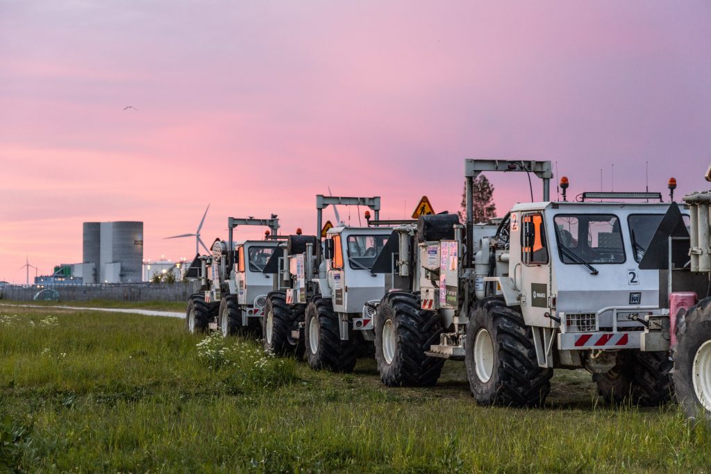
The use of STRYDE’s miniature nodal seismic technology allowed RTS to record seismic data discreetly, positioning the seismic nodes along streets, in bushes, and next to trees, hidden away from the public where possible. Nodes were clearly marked with notes explaining the survey, and amazingly, less than 1% of them were tampered with.
To further minimize disruption, Innargi reduced source efforts near historic and vulnerable buildings and conducted operations at night, ensuring minimal disturbance to the local community.
As a result, the survey was virtually invisible to most passersby or local residents. The only indication that a survey was taking place was when the Vibroseis trucks passed quickly through the streets at night for the source operations.
“We were pleasantly surprised by how few nodes were tampered with,” Emil noted. “People were curious but generally respectful. Some even mailed back nodes they had picked up!”
Ensuring high-resolution seismic data was acquired and delivered quickly
“The ability to deploy a dense seismic node network without disrupting road traffic or daily life in the city was crucial.” said Claudio Strobbia from RTS. “We leveraged our fleet of STRYDE nodes to acquire the data efficiently.”
Thanks to the compact size and autonomous functionality of these nodes, RTS was able to deploy a high-density array with just 10 meters between each node, all while avoiding additional costs. This dense array, combined with nighttime operations to minimize anthropogenic noise interference, resulted in data quality that exceeded expectations.
“In our experience, urban environments are notoriously challenging for seismic acquisition, but the results we obtained on these two surveys were exceptional. The combination of a dense receiver grid, long offsets, and optimized source effort enabled us to produce highly accurate subsurface images.” added Claudio.
Once the data was acquired, RTS processed it with exceptional speed, delivering high-resolution seismic images for Innargi in record time. These insights played a crucial role in refining the geological model, mapping fault lines, and pinpointing the most promising locations for geothermal wells.
RTS migrated images just hours after acquisition to conduct initial checks, with full processing completed within weeks. For the Copenhagen survey, operations wrapped up mid-June, and by mid-July, Emil, and his team were already reviewing the initial data, with the final processed versions and report completed by August.
RTS’s approach contrasts sharply with traditional, larger processing firms, where the process is often found to be slower. “Working with RTS, I experienced a highly interactive and tailored service, ensuring that queries were resolved quickly, rather than waiting for weeks on end to see results.” Emil commented.
The impact on Denmark’s energy future
The success of these seismic campaigns has already translated into real-world impact. In Aarhus, Innargi’s first geothermal facility, informed by the seismic survey, is set to begin producing heat in September 2025. In Copenhagen, the data has guided site selection, which will ensure that future geothermal wells are optimally placed for maximum efficiency and longevity.
“This was a hugely rewarding project,” Emil reflected. “Seeing something that started as an idea on paper transform into a fully operational geothermal plant is incredibly exciting.”
Learnings for future urban geothermal exploration
The success of these projects highlights the transformative impact of full transparency with local communities, adaptable survey design and operations, autonomous seismic technology, and advanced data processing in urban geothermal exploration.
One of the most critical factors affecting data integrity is shot point gaps. “In urban environments like Copenhagen and Aarhus, access constraints, road bends, and infrastructure limitations made it challenging to achieve consistent shot point coverage. While missing a few nodes in a dense receiver layout is manageable through regularisation, larger gaps in shot points are much harder to compensate for, making it essential to minimize them wherever possible.” said Claudio.
“Looking back on how we could have further improved efficiency, reducing source effort and deploying two smaller fleets simultaneously could have improved shot point coverage while increasing acquisition speed and minimizing disruptions. While long offsets can provide valuable data, a 6 km offset was found to be sufficient for these geothermal targets, as longer distances resulted in diminishing returns,” added Claudio.
With STRYDE’s innovative nodal technology, RTS’s expert seismic acquisition and processing, and Innargi’s geological expertise and commitment to sustainable energy development, this project serves as a benchmark for future geothermal initiatives in densely populated regions.
As Europe moves toward a greener energy future, the success of these Danish projects demonstrates how advanced seismic acquisition is rapidly unlocking new opportunities in geothermal energy, helping cities transition away from fossil fuels and toward a more sustainable future.